
Where Spring Water Begins
Recharge, flow paths, and the hidden journeys beneath our feet

Larry is away this week at the Smithsonian, presenting to a group of paleontologists about spring ecosystems and the long ecological histories they preserve. Back in the office, the rest of us are deep in proposal writing, working to secure what we hope will become the next generation of SSI projects. I am also currently neck-deep in building a Colorado River food base model and developing a process-based reach framework for the Colorado River Basin that integrates hydrology, network structure, and geology. It has been a week immersed in how water moves across landscapes, through aquifers, and along river networks, which feels fitting for this issue.
In that spirit, this week I want to step back and provide a high-level overview of where the water in springs originates and why no two springs are hydrologically identical. Although springs are often grouped together as a single type of feature, each one reflects a distinct combination of recharge source, flow path, geology, and groundwater travel time. Understanding those differences is central to understanding springs themselves.
Water does not arrive at a spring by accident. It begins somewhere else, as snow on a plateau, rain on a forested slope, or a storm crossing desert rock, and then moves downward through soil, fractures, and pore spaces in rock. Along the way, it is shaped by geology and driven by gravity. It may move quickly or slowly. It may travel shallow pathways or descend deep into regional aquifers. Eventually, where subsurface conditions allow, that groundwater returns to the surface as a spring. We use a single word to describe this reemergence, but springs are hydrologically diverse. Some appear as small seeps or trickles sustained by shallow perched aquifers. Others discharge forcefully from canyon walls, reflecting large, well-connected groundwater systems. The differences we observe at the surface are expressions of very different flow paths, recharge sources, and groundwater travel times beneath our feet.

Two well-known examples in the American Southwest illustrate this variability clearly: Vaseys Paradise in the Grand Canyon and Montezuma Well in central Arizona. At Vaseys Paradise, water emerges from the canyon wall in a lush hanging garden above the Colorado River. The hydrologic system feeding this spring is relatively compact. Much of the recharge originates on the North Rim, less than 15 kilometers away. Snow and rainfall infiltrate the Kaibab Plateau and move through fractured limestone toward the canyon. Portions of this groundwater can travel quickly — in some cases on the order of hours to days — while other fractions move more slowly, taking years. Overall, however, the system responds measurably to contemporary climate. Wet winters, snowpack variability, and seasonal precipitation patterns can influence discharge. Vaseys Paradise is closely tied to present-day hydrologic conditions.
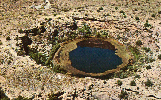
Montezuma Well operates on a very different scale. The water discharging into this travertine-lined basin travels approximately 100 kilometers from recharge areas on the Colorado Plateau. Rather than responding rapidly to seasonal precipitation, the system integrates recharge across large spatial and temporal scales. Isotopic analyses indicate groundwater travel times on the order of 5,400 to 13,000 years. The water emerging today began its journey in the late Pleistocene. Its discharge reflects long-term aquifer dynamics rather than recent weather patterns. The hydrologic response to climate is strongly lagged, buffered by the depth and extent of the regional groundwater system.
Although both sites are described simply as “springs,” their underlying hydrology differs fundamentally. Vaseys Paradise represents a relatively short flow path with a dynamic connection to modern recharge. Montezuma Well reflects a deep, regional system with long groundwater residence times and delayed climatic response. These differences influence not only discharge behavior but also vulnerability and management considerations.
A spring supported by a short flow path may respond quickly to land use change, wildfire, or short-term drought. Alterations in recharge conditions can affect discharge within years. In contrast, a spring fed by ancient groundwater may appear stable even as regional groundwater withdrawals or long-term climatic shifts alter aquifer pressures. When change does occur in these deeper systems, recovery may take decades or longer, depending on recharge rates and aquifer properties.
Understanding springs therefore requires more than measuring flow at the point of emergence. It requires characterizing recharge sources, delineating flow paths, estimating groundwater travel times, and evaluating how each system responds to climatic and anthropogenic stressors. Springs are not uniform features on a landscape; they are surface expressions of groundwater systems operating on different spatial scales and time horizons.
Some springs reflect water that fell during the last storm. Others discharge water that infiltrated thousands of years ago. Recognizing this variability is essential for effective stewardship. Each spring operates on its own hydrologic clock, and conservation strategies must be aligned with the scale and dynamics of the system that sustains it.
As always, we are interested in hearing from our readers. If there is a particular topic you would like us to cover, please reach out in the comments. For those of you with a Substack account, responding there is straightforward. If you engage with this newsletter via email, it is easy to create a Substack account and join the discussion in the comments as well. You are also welcome to reply directly to this email, and we will receive it. And if you know someone who might find our writing interesting, please share it widely — we would like to continue building this community of readers interested in springs science and stewardship.